From Ancient Rome to Google
Over the centuries Tuscany and Chianti have been depicted in many different ways. From the allegorical to the digitally photographed, each representation has said something about the era in which it was created and much about the importance of this part of the world.
The above is a detail from the extraordinary Tabula Peutingeriana, probably dating to the 5th century CE, which depicts all roads leading to Rome; this section covers Tuscany with Florence (Florentia Tuscorum) and Siena (Sena Julia) in the lower centre. For a look at the complete Tabula, which is glorious, see here.
 |
| Leonardo da Vinci, 1502 |
Leonardo da Vinci's marvellous, idealised bird's eye view of the rivers running through Tuscany towards Lake Trasimeno, executed in about 1502 when he was working for Cesare Borgia for military-strategic or engineering (study of waterways) reasons.
Panzano is noted in the bottom left hand corner, as is the Pesa.
 |
| The Allegory of Chianti by Giorgio Vasari, Sala del Cinquecento Palazzo Vecchio, Florence, from 1555. |
Note the gallo nero or
Chianti black rooster in Vasari's fresco. Other allusions are to wine,
fruits, possibly olive oil and rivers. The castle in the background
resembles the castle of Brolio, belonging to the Ricasoli family, see
below.
 |
| Ricasoli family tree |
The family tree above, belonging to the Ricasoli family, the family as far as Chianti and its wines are concerned, was created in 1584 and is remarkable for its depiction of Chianti below the tree
 |
| Le Piu' Antiche Immagini del Chianti |
This volume Le Piu' Antiche Immagini del Chianti by Francesca Marchetti and Donatella Tognaccini, examines in detail the images of Chianti in the Ricasoli family tree document. At the time and since the end of the 15th century, Chianti was defined as the area controlled by the Lega del Chianti, a union of three Communes, Radda, Castellina and Gaiole, under the aegis of Florence. Le Ripe was and is in the centre of this area. Later they were joined by the Communes of San Casciano, Tavarnelle Val di Pesa, Barberino Val d’Elsa, Greve and Castelnuovo Berardenga.
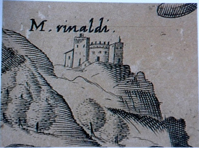
The charming detail of Monte Rinaldi, a property near Le Ripe, from the Ricasoli family tree can be compared to another, almost contemporary representation of the same property as it appears (below) in the Mappe dei Capitani di Parte Guelfa, (1580-1595) or maps of the Guelph Captains which were drawn up to calculate the maintenance costs of the various public roads and which at times reveal some interesting details. These Mappe appear in two different versions: the preliminary sketches, presumably done in situ, and the final drawings. It has been suggested that the former are more reliable than the latter. In addition the Mappe representations of buildings, drawn up for practical purposes, often differ greatly from the Ricasoli depiction, intended to enhance an image of venerability and power.
Below it is possible to compare three drawings of Panzano, all from the same period: first the Mappe preliminary sketch, with considerable detail, then the Ricasoli rendering, then the final version of the Mappe.
Below are the two 16th century representations of Radda, first the Ricasoli, then the final version of the Mappe. The contemporary photograph of the town makes for an interesting comparison.
Finally, in black and white below, an image from the Mappe of Grignano, the building with the tower on the right, a locally famous (it appears on postcards) medieval castle with tower, around the corner from Le Ripe, on the 222 towards Castellina. The buildings to the left belonged to a relative of Galileo Galilei, no small source of pride in these parts: and did those feet in ancient times walk upon Chianti's mountains green?
Here instead is a detail from the pages dedicated to the Dominio Fiorentino in the Atlas Maior of the Dutch cartographer Joan Blaeu from 1665. Here is Chianti with Greve, Panzano, Radda and even Grignano clearly marked.
The following map is our pride and joy for it is the first time that Le Ripe appears (as Ripuzza) in any map we have seen. It was drawn up by the cartographer Ferdinando Morozzi in 1784. It was Morozzi who wrote the 1770 volume on On Farmers' Houses, already cited in our post Le Ripe's history
 |
| You'll have to take our word for it: this reproduction is unclear |
 |
| detail from another version by Morozzi from the same period: Ripuzza is at 10 o'clock from Radda, past San Pietro and Vignale |
Now for the Catasto Leopoldino: begun in the 18th century as part of a great effort to register, for tax purposes, all properties in the Duchy of Tuscany, the Leopoldian Register was subsequently suspended for decades and resumed in 1825. The section which includes Le Ripe dates from this latter period. The name has altered slightly again, to Le Ripacce, although there one of the streams on the property is called Borro Le Ripucce.
In the modern road map below, published by Kompass in 1985, we found that Le Ripe is most felicitously placed, right next to the A in the middle of CHIANTI, literally!
Then of course, the 21st century version, available to all at the click of a mouse: Googlemaps.
With many thanks for information, documentation and expertise to Professor Italo Moretti who gave us the volume Le Piu' Antiche Immagini del Chianti from which some of the images above have been taken. And thanks to De Rerum Natura for all the detective work and gathering of materials.


These ancient maps reveal so much of the local history which is so fascinating to relate to a modern context.Warm thanks to the history archivist to whom we are so grateful.
ReplyDelete